Lebanon
Lebanon is a country situated in the scope of Med-O-Med program, geographical and culturally. That is why and with the objective to use them as reference for the different research and catalogues created by the program, that we present this data for the country in different subjects.
MAIN PHYTOGENETIC RESOURCES OF LEBANON AND THE MAIN THREATS
Lebanon has very rich biodiversity, mainly because of its mountainous landscape and the extremely varied climate. Forests cover 7.7% of the country’s land surface. Vegetation is typically Mediterranean along the coastal strip and in most of the lower regions. Firs, beeches and cedars are to be found in some parts of the northern mountains at altitudes of 1,200-2,000 metres. Dense pine and oak forests cover the slopes of the southern mountains.
There are 4,633 plant species and 4,486 animal species. More than half of the forage plants (45.2% of ferns, 41.3% of endemic plants and 6.8% of medicinal plants) are at risk of extinction. Several species of fauna are also at risk of extinction, and many species have been lost over the last century, including the Syrian brown bear, the Asian leopard, the Persian lynx and the gazelle.
Some of the main threats for biological diversity are pressure from urban development, lack of public awareness, monoculture, invasive exotic species, deforestation, pollution, water demand, etc.
STATUS OF IN-SITU AND EX-SITU CONSERVATION
In-situ conservation
There are 8 protected areas in Lebanon covering 1.8% of the country’s surface area (2006). The National Strategy for Conservation of Biodiversity and the Plan of Action describe the need for a national data base on the country’s biological diversity so that agricultural biodiversity can be monitored, with expansion and management of the protected areas system, and protection of the various ecosystems and biological resources, especially native species.
In order to safeguard the remaining forests, the Forestry Law was amended in 1996 and now stipulates that all cedar, fir, juniper and other conifer forests must be protected. As a result, 15 forests (including the Karma Chbat Reserve, the Saissook Nature Reserve, and the Tannourine-Hadath and el-Jobbe Reserves) were declared protected areas by the Ministry of Agriculture. Moreover, many rivers, mountains and valleys fall under the protection of the Ministry of the Environment. 8 sites in Lebanon were declared nature reserves and another 2 are in process.
Ex-situ conservation
The Lebanese have always used native plants as ornamental plants – oaks, cedars and European nettle (Celtis australis). The National Strategy aims to develop the reproduction of native species in nurseries. This strategy lays down a plan of action for the short term (1-3 years), which includes the creation of zoos and aquaria, the fostering of public awareness on the quality of local biological diversity and strict enforcement of regulation on germplasm imports. In the medium term (3-5 years), the plan lays down the following priorities: the creation of botanic gardens in cities and the use and conservation of local germplasm. In the long term (5-10 years), the priorities are programmes to restore degraded zones as well as the creation of germplasm banks and technological facilities for tissue cultivation.
The Lebanese Agricultural Research Institute, which is run by the Ministry of Agriculture, has several experimental stations and botanic gardens in different parts of the country. Also, Beirut American University has a Natural History Museum and a Herbarium.
Centers of plant diversity
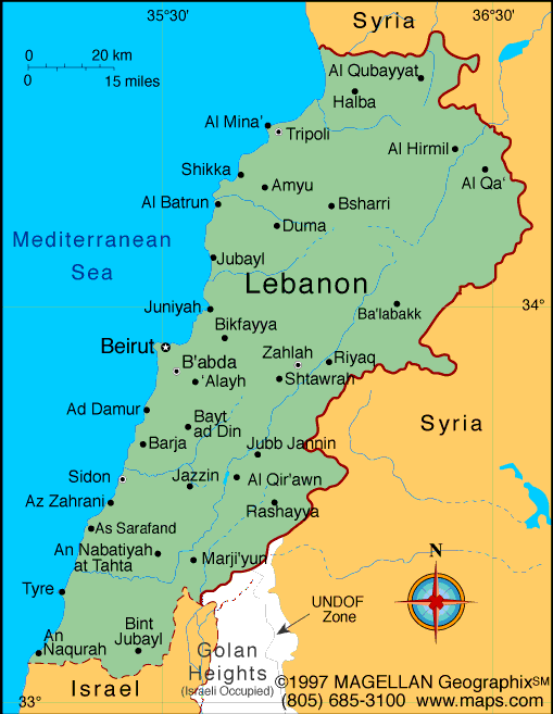
 Lebanon is in the Near East, to the west of Asia, and its western frontier is the Mediterranean coast. To the north and east, Lebanon borders on semi-desert lands in Syria, and to the south it has a short frontier with Israel.
Lebanon is fairly mountainous. It can be divided into four main structural units from west to east: first, a fairly narrow coastal strip where most of the main towns are located; second, the Lebanon Mountains, a limestone mass reaching above 3,000 metres; thirdly, the Bekaa synclinal depression; and, finally, the Anti-Lebanon Mountains, forming the natural border with Syria. Along the coastal strip there are stepped terraces formed during the Pleistocene rising to 100 metres above sea level. The Lebanon Mountains, which are higher in the north than in the south, reach their maximum height and the maximum for the whole country, at the Qurnat as Sawda (3,088 metres). The Anti-Lebanon Mountains to the east rise to 2,814 metres in their southernmost part. Both ranges are mostly Mesozoic limestone from the Jurassic and Cretaceous because they formed a single system that was split in two when the Great Rift Valley was formed. The sunken part is the Bekaa valley, at altitudes between 800 and 1,200 metres.
Two factors influence the climate of Lebanon: relief and proximity to or distance from the sea. A distinction can therefore be made between the coastal climate, which is fairly moist and warm, with very Mediterranean characteristics; the mountain climate with cold winters and frequent frost; and, further to the east, the arid, dry climate. In Beirut, annual rainfall is 800-900 mm and average temperatures in January and August are 14.4°C and 25.6°C, respectively. The synclinal depression is much drier, with less than 400 mm of rain a year.
Lebanon is a country situated in the scope of Med-O-Med program, geographical and culturally. That is why and with the objective to use them as reference for the different research and catalogues created by the program, that we present this data for the country in different subjects. This post is available in: English Español