Tunisia
Tunisia is a country situated in the scope of Med-O-Med program, geographical and culturally. That is why and with the objective to use them as reference for the different research and catalogues created by the program, that we present this data for the country in different subjects:
MAIN PHYTOGENETIC RESOURCES OF TURKEY AND THE MAIN THREATS
Turkey is like a small continent in terms of biological diversity. It has three different types of bioclimate and three bio-geographical areas: Euro-Siberian, Mediterranean, and Irano-Turanian. For these reasons, Turkey has a high level of plant biodiversity, especially seed plants. The Irano-Turanian region has the largest number of endemic species, followed by the Mediterranean and Euro-Siberian regions.
Turkey has about 1,000 known species of lichen, and the figure is constantly increasing. About 740 species of moss are estimated to exist in Turkey. Ferns (8 species of Equisetaceae, 6 species of Lycopodiaceae and about 80 species of Philicineae) are the most widespread plant group, together with seed plants. They grow in all parts of Turkey, except for very arid areas, especially in the Black Sea region. The number of species and sub-species of fern identified in Turkey is 101, of which only 3 are endemic.
There is a low level of endemism in gymnosperms, with just 5 endemic taxons at variety and sub-species level. However, the level is very high for angiosperms, where the number of identified plant species is currently about 9,200. The number of species and sub-taxons of species is 11,000. 34% of species in Turkey (3,150) are endemic.
The endemic species are mostly found in mountainous areas and in specific habitats. Places with high rates of endemism include the Amanos, Sandras, Bey, Bolkar and Ala, Uludağ, Kaz and Munzur mountains.
The Compositae family is the richest in terms of endemism, with 435 endemic species. The Leguminosae come next, with 400, and are followed by the Labiatae, with about 310. Astragalus is the richest genus, represented by approximately 250 species, followed by Verbascum with 175, Centaurea with 115 endemic species and Hieracium with 66 species. The level of endemism is 100% for the Ebenus (14 species) and Bolanthus (6 species) genera.
STATUS OF IN-SITU AND EX-SITU CONSERVATION
National programmes for ex-situ and in-situ conservation are laid down in Turkey’s National Strategy for the Conservation of Biodiversity. Ex-situ conservation is carried out through Germplasm Banks, seed banks, zoological parks, botanic gardens, etc. Turkey is especially interested in ex-situ conservation being carried out as a complement to in-situ conservation.
In-situ conservation
The proportion of protected areas over the country’s total surface area rose from 4% to 6% after 2000. Turkey’s 39 National Parks are of great importance for conserving the biological diversity of forests, steppes, wetlands and coastal ecosystems. Areas for the conservation of nature are defined in Turkey as “natural areas comprising ecosystems at risk or vulnerable, with the presence of exceptional items (species) and/or natural phenomena of special relevance for science and education, which require total conservation for a variety of reasons”.
In addition to its National Parks, Turkey also has 80 areas for the development and conservation of fauna, which protect and maintain the necessary habitats. There are also 104 locations catalogued as “Natural Monuments”.
The concept of “Area for conservation and genetic management” was drawn up in 1993-1998 (GEF-1 Project) in the framework of the Strategy for the Protection of Genetic Diversity in Turkey. These areas have been chosen for the in-situ conservation of genetic diversity of selected plant species.
Turkey joined the Ramsar convention in 1994 and, during the accession stage, its 5 wetlands (Manyas Lake, Seyfe Lake, Burdur Lake, the Sultan’s Reedbed and the Göksu Delta) were included on the convention list. Subsequently, others were added – the Gediz Delta, Akyatan Lagoon, Uluabat Lake and the Kızılırmak Delta. Today, Turkey has 12 Ramsar wetlands covering a total surface area of 206,830 ha.
Ex-situ conservation
Conservation activities in Turkey began in 1964 at the Aegean Institute for Agricultural Research, run by the Turkish Ministry of Agriculture and Rural Development (MARA). Seeds representing Turkey’s plant genetic resources were first conserved in the long term (basic collections) and in the medium and short term (active collections) at the National Germplasm Bank that was set up in 1972 as part of the Institute.
The national collection includes samples up to variety level, as well as wild and herbaceous relations of plants that are of economic interest, such as medicinal, aromatic and ornamental plants, as well as the country’s endemic species, certain species that are peculiar to south-west Asia and a small collection of the world’s wheat and barley varieties.
About 50,000 samples of about 600 genera are conserved in the National Germplasm Bank. Of them, about 10,000 belong to 2,400 wild species. The National Strategy and the Plan of Action on Biological Diversity cover several seed banks in different provinces such as Yalova, Izmir, Tekirdağ, Gaziantep, Malatya and Erzincan, which mainly include collections of fruit species.
Falling outside the scope of the MARA is the Osman Tosun Germplasm Bank in the Faculty of Agronomy at the University of Ankara, which has been active since 1936 with medium-term conservation facilities. This organisation holds about 11,000 samples of seed. The University of Çukurova and the Aegean University also carry out ex-situ conservation, as do the botanic garden at the latter, the University of Istanbul Botanic Garden and its Ataturk Arboretum. Other botanic gardens and arboretums have been established thanks to private initiative over recent years (Nezahat Gökyiğit Botanic Garden, Karaca Arboretum, etc.).
Centers of plant diversity
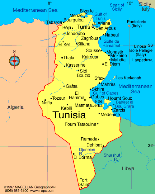
 Tunisia, with a surface area of 164,418 km², is in North Africa, between the Mediterranean Sea and the Sahara desert, and between Algeria and Libya. About 40% of it is desert, and the remainder is made up of fertile lands.
In the north there are mountains and the climate is temperate, with mild, rainy winters and hot, dry summers. Temperatures in the north range between 34 and 6ºC. In the south there are deserts leading down to the Sahara.
Southern Tunisia is arid, but in the north there are pine forests, with pastures for cattle in the northwest and orchards and vineyards along the eastern coast. Only 19% of the land can be cultivated, although 13% of this is irrigated. The highest peak in Tunisia is Jebel Chambi, to the north of the city of Kasserine, at 1,544 m.
Tunisia can be divided from north to south into various topographic regions that are easy to distinguish.
Starting in the north and going southwards, there is a series of mountain ranges including the Atlas in the Tell region, occupying the northern half of the country and crossing it from south-west to north-east, with elevations ranging between 610 and 1,544 metres, the latter being Tunisia’s highest point (Jebel Chambi). In these territories, there are both fertile valleys and plateaux with mountains. This is the starting-point for Tunisia’s longest river, the Majardah, which flows from west to east into the Gulf of Tunisia.
Towards the south, the landscape changes, with the mountains giving way to a plateau at an average altitude of 610 metres. This gradually drops down to an area of salt lakes, known as shatts o chotts, which stretch from east to west and are mostly at sea level. The most important of these lakes are the Djerid and Bizerta. This area is semi-desert steppe. In the southernmost part, the shatts end up at the Sahara desert, which occupies 40% of the total surface area of Tunisia. In the area between the shatts and the desert, there are many oases, especially around the city of Gabes which lies at the centre of the gulf of the same name, close to the frontier with Libya. About 400,000 date palms flourish in this area of large oases.
To the north, Tunisia borders with Algeria. The frontier is one of rough terrain in the area of the Atlas mountains, except for the northernmost part where it is formed by the El Kala natural park in Algeria. These natural frontiers continue all along the mountain range that crosses Tunisia, but when it descends and merges into the Sahara desert or, more specifically, at the Grand Erg Oriental, the frontier with Algeria becomes a straight line because there are no geographic features that can form a frontier. The frontier with Libya is mostly marked by high plains in the Libyan region of Tripolitania. According to WWF, the Tunisian territory comprises five ecoregions:
- North African montane woodlands in the North-western mountains
- North African Mediterranean woodlands along the coast and in the northern half of the country
- Mediterranean shrubland steppe in the centre
- North Saharan steppe in the southern half
- Saharan saltmarshes in several wetlands in the centre and north of the country
Tunisia is a country situated in the scope of Med-O-Med program, geographical and culturally. That is why and with the objective to use them as reference for the different research and catalogues created by the program, that we present this data for the country in different subjects: This post is available in: English Español